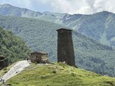
Add organization

    Ushguli

    🏔️ Municipality: Mestia Municipality
    🌍 Region: Samegrelo–Zemo Svaneti, Georgia
    📍 Location: Upper Enguri River valley, near Mount Shkhara
    🛣️ Nearest town: Mestia (~45 km via mountain road)
    🏘️ Status: High-altitude village (community of several hamlets)
    👥 Population: approx. 200–300 residents
    ⛰️ Elevation: approx. 2100–2200 m above sea level
    🏰 Known for: Svan defensive towers and UNESCO World Heritage status
    Time zone: GET (UTC +4)
    ❄️ Climate: Alpine, snowy winters and cool summers

    The Most Frequent Questions

    ❓What is the distance to Ushguli from Batumi?

    The distance from Ushguli to Batumi is 182 kilometers in a straight line, 288.4 kilometers along the pedestrian route, 308.7 kilometers along the highway.

    ❓What is the distance to Ushguli from Tbilisi?

    The distance from Ushguli to Tbilisi is 200 kilometers in a straight line, 415.6 kilometers along the pedestrian route, 382.9 kilometers along the highway.

    ❓Where is Ushguli?

    Ushguli is located in the Mestia municipality of the Georgian region of Samegrelo-Zemo Svaneti. This is a Svan community popular with tourists, consisting of five villages: Zhibiani, Lamjurishi, Murkmeli, Chazhashi and Chvibiani.